Every year I try to get to the Nottingham Model Railway
Exhibition, held in Bilborough, on the north western edge of Nottingham.
Naturally, I walk there and back - weather and time permitting. Rather
than use the shortest route, I try to add a bit of variety each time.
This brings the walk up to around 25 to 30 miles.
This
time, I headed out through Kirkby, Annesley, Greasley, Awsworth and
Strelley. I returned through Aspley, Old Basford, Bulwell Common,
Hucknall and Newstead. The outward leg was a good opportunity to cover
several sections I had not tried before. The weather was really warm and sunny for most of the day.
I
set off about 6:45am. This is very early for me, but works out very well for me
to see the exhibition and complete the walk in daylight. I was armed with my new camera. It had only arrived the
previous day. I had no chance to experiment with it before putting it
to good use.
I headed south from home, passing the western edge of Kirkby before entering Portland Park.
I then headed through Annesley and down the main road past the original Annesley Church. Just beyond Annesley Hall, I turned left onto Weaver's Lane. The local farmer had already been busy ploughing a field at the side of the lane.
I turned left onto Kennel Lane before entering the woodland just north and west of Misk Hill. I followed the path under the motorway, then left and south towards Watnall.
The path eventually comes out of the woodland near Misk Farm. At the motorway footbridge, I turned right and headed south west, just to the left of the woodland you see in the middle of the photo below..
The path quickly comes to a narrow road joining all the farms in these parts. I turned left towards Brooksbreasting Farm. Immediately before the farm, a footpath goes diagonally west for a short distance before turning south down a small valley towards Greasley Church. This is a view west from the top of the footpath.
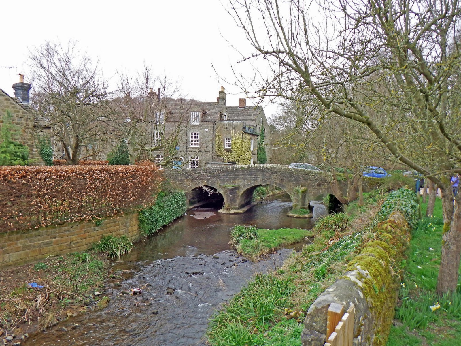
After a few twists and turns, we arrive at the small hamlet of Greasley. Today, it is little more than a church, tea rooms, a farm and one other large house. This view shows Greasley Castle Farm.The church is off to the right.
The farm is the site of a very old manor house, later fortified. Few remains exist, but this wall is said to be part of the castle wall. Traces of a moat were found in the foreground during excavations.
There are rumours of a lost village somewhere in the vicinity of the church, as this sign explains.
This is also on the edge of D H Lawrence territory.
I walked past the church before climbing some steep steps into the graveyard, following a footpath south west towards Newthorpe. The church sits on a hill, deceptively small from the main road, but much more impressive from the rear. Unfortunately, the fields behind the church were part of an opencast coal mine and have been landscaped in a very plain manner. The fields do not drain very well and were still very muddy, despite several weeks of dry weather.
Just beyond the bottom of the hill, I turned left along the path towards Watnall. This eventually crosses a small stream at the bottom of a valley. Here, I turned south towards Awsworth. This path follows the stream all the way to the B6010 road. Quite a culture shock on the other side of the road!
I carried on south west under the A610, then up the road through Awsworth Village. Just through the main section of the village, I turned left along the road to Babbington. A short distance down this road, the route to Babbington goes sharp left. I carried straight on along the bridleway towards Strelley. Cossall village was visible on the right, on the horizon.
By now it was turning into a really warm, sunny day. Looking west, Ilkeston was just visible in the distance.
The bridleway turns east near Strelley Park Farm. I should have turned right at the farm, but carried on a short way up the hill by mistake. The lane becomes a private drive not far beyond here...
..so I quickly realised my mistake and returned to the farm to get on my correct route. The bridleway continues south east before turning east to Strelley Village. There is a fairly steep climb. Looking back, Ilkeston was clearly visible in the distance.
The bridleway crosses the M1 just before Strelley Village.
Strelley village has a large Hall, a church and a small collection of cottages. It is also known for Monks Way, a length of very old paving stones.
Some of the paving stones skirt these buildings near the church.
Strelley Church sits in a tiny churchyard. It is surrounded by trees and difficult to photograph.
The frontage of the Hall is only really visible from a distance.
Bilborough is hardly photogenic, so I took no further photos until I got inside the model railway exhibition. Here is a small selection of the goodies on show. Firstly, South Yard, a tiny layout around 2 feet long in a scale of 1:152, or 2mm to the foot. It is owned by Andrew Carlson, a friend of mine.
Manston Brewery was built by Rob Milliken, another acquaintance. This is in 4mm to one foot scale, or 1:76.
At the opposite extreme was Aberbeeg, a huge layout in 7mm to one foot scale.
The models were not all of railways. These lorry models were very skilfully made.
Back to the walk, I headed for Old Basford and Bulwell Forest. Alongside Bulwell Forest, an old railway line has been converted into a footpath paralleling the A611 towards Moor Bridge.
This continues alongside the B683 to Bestwood Village, before crossing into Bestwood Country Park. This is in the valley of the River Leen, which I followed all the way north to Annesley. Inside the park is a large lake, with plenty of water birds.
North of Bestwood Country Park, my trail led onto Wigwam Lane in Hucknall, past the remains of Hucknall Colliery - now converted to an ugly industrial estate on the western side of the road and a golf course to the east. At Hucknall, I passed the railway station and took the road north towards Linby. On the edge of Linby Village, the old railway track is a footpath once more, up as far as Newstead Village. Here is a view looking south along the path I had just traversed - taken just south of Newstead.
Beyond Newstead, I headed for Annesley Church - the "new" one. This was built in 1874, though services continued at both sites until 1942.
Beyond the church, I headed down to the main road, retracing my steps through Portland Park and past the western side of Kirkby, before reaching home about half an hour before sunset.
Excluding my circuit of the model railway exhibition, the walk was 29 miles long. After my struggle to do even 2/3 of that distance the previous week, I should have felt very pleased and relieved. The only snag was that I had another gruelling walk in the Peak District to look forward to the following day.
As for the new camera, I am impressed with the results - though the images here have been reduced in size on my computer, for convenience.