The route took me through the grounds of Chatsworth House along the Derwent Valley, before turning east, up onto Beeley Moor. I then headed south east across high ground towards Tupton. From here, I headed a short distance north east to the Five Pits Trail, which took me south to Tibshelf. I then turned east along the Teversal Trail.
I hitched a lift with the Sutton in Ashfield Rambling Group as far as Baslow. They were off to Eyam, for a walk back to Baslow. I decided to do my own thing today, as it meant I could do something a little more challenging!
I crossed the Derwent at Baslow and turned south along the Derwent Valley Heritage Way. This was the view looking back to the old bridge at Baslow.
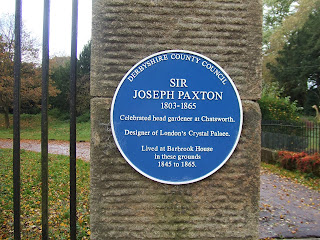
I soon entered the grounds of Chatsworth House. Amongst other things, this is famous for some of the work of Sir Joseph Paxton, designer of the Crystal Palace in London.
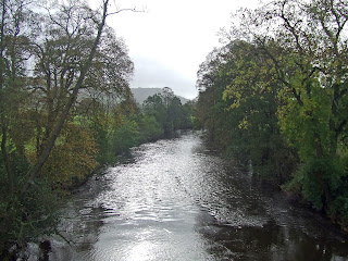
The valley is very pleasant through the park. This is a view looking north towards Baslow.
Chatsworth House itself is a very impressive landmark in the valley. Here is a view from the south west, after I had crossed the river.
...and here is a slightly more distant view. I was soon to turn east and climb the ridge you see to the right of the house.
I crossed the river again at Calton Lees. Here is the approach to the bridge. The grass was very wet from the recent rains - a warning of ground conditions later in the walk!
This was my last view of the Derwent, looking south from the bridge.
I then headed due east, up a narrow road towards Beeley Moor. The climb is about 200 metres. A short way up the hill, I saw my first rainbow of the day, looking north west over Chatsworth House.
Part way up the hill, there are farm buildings at Beeley Hilltop. From there, the road is a rough track.
This was the view south east towards the Derwent Valley. I took this during a brief shower, as witnessed by the spot of rain on the lens!
At the top of the hill, I walked along the road from Beeley village, before turning off along a minor road towards Holymoorside. This was my final view to the west, from the road junction.
I then took another minor road down a quiet valley to Harewood Grange Farm. This is a view of the farm, looking east from the road.
From the farm, I took a bridleway east across Harewood Moor. This view shows Harewood Grange Farm from the east.
Harewood Grange is on the other side of the valley to the farm. This view, looking north, shows the Grange and the valley through to Holymoorside on the right.
I saw another rainbow (one of several this day) a little later, again looking towards Holymoorside.
The bridleway took me to Walton Leys Farm, where I experienced a brief, heavy shower. I turned left along the B5057 to the Red Lion Inn at Stone Edge, otherwise known as the Peak Edge Hotel. This interesting rock was on the opposite side of the road.
Immediately beyond the pub, I turned right (south east) along a footpath towards Tupton. This stretch was by far the most difficult of the walk. The fields were very wet, with standing pools of water and deep mud in places. The route of the path was not at all obvious in parts. Nevertheless, there were some fine views the the east and the north east - and yet more rainbows!
This shot, from just east of the A632, shows some of the mud, as well as the view over towards the east.
And this was a view north to Chesterfield, with the famous crooked spire in the middle of the picture.
The path eventually came out at Birkin Lane Farm, where I turned left along a minor road for a short distance, then right again along another footpath downhill towards Press. At the minor road to Press, I turned left, heading north towards Bole Hill. At the top of the hill, I reached some thick woodland. I turned right along a path through the southern edge of the woodland (Hardwick Wood). There was another heavy shower here, but I was largely sheltered by the trees. This was the view south from the woods, towards Clay Cross.
The path through the woods was difficult to follow, as it was hidden by a deep layer of newly-fallen leaves. Fortunately, the path more or less followed the edge of the woods, so it was not difficult to take an educated guess as to where I should go. The path turned east, along the southern edge of the woods, before opening out into fields. This led onto a bridleway to Old Tupton and the A61 road. I briefly turned south at the main road before turning east again at the roundabout. I then took the road east towards North Wingfield. This dips down to the railway line. I crossed the railway and then headed up a steep trackway to the north east. The line of the trackway is shown by the hedgerow in the distance, on this photo taken from the railway bridge.
I think the trackway was once a railway incline leading up to collieries at the top of the hill. This was the view looking back to the west from around halfway up the incline.
The trackway ends at the northern extreme of North Wingfield. I turned briefly north along the main road, then right, onto a branch of the Five Pits Trail. This is not signposted, but is not difficult to spot from the road!
The Five Pits Trail and its branches are more or less along the trackbeds of old railway lines, so provide a fast, easy way to progress through the countryside. This quickly leads to a junction of the Trail at Wolfie Pond - for once totally devoid of anglers.
Just south of the pond, I took this shot, looking north west towards Chesterfield.
The weather was very changeable though! The beautiful blue sky soon darkened to give another heavy shower near Pilsley. To the east, Crich Stand was just visible in the middle of this shot.
The Five Pits Trail ends just south of Tibshelf. Just to prove that I made it there, here is a shot from the end of the trail, looking north.
From here, I turned east again, along the Teversal Trail. By now, I was aware that it would soon start to get dark. I got to Huthwaite about half an hour before darkness arrived. I decided to leave the trail here, at the Woodend Inn. That way, I could make my journey home under the glow of street lights, all the way. This was my last view of the Teversal Trail, looking east from the bridge next to the Woodend Inn.
I had long fancied doing a walk through Chatsworth Park and up onto Beeley Moor. This walk achieved that - and a lot more. The distance was shorter than many of my long walks, but the muddy section in the middle was very tiring. With darkness arriving just after 5pm, it would have been difficult to walk much further without the aid of street lights. Apart from a couple of heavy showers, the weather was much kinder than had been forecast, too. All in all a very good day!


No comments:
Post a Comment